By Shannon Lukens.
FINAL UPDATE FROM BUREAU OF LAND MANAGEMENT – 1:15 p.m. Tuesday, Oct. 3
“The Iron Fire is 75% Contained. Widespread precipitation was received over the fire area, more showers are expected today. All Moffat County Roads will open back up on Wednesday.” From Patrick “PK” Kieran, the Fire Management Specialist with BLM Colorado.
Iron Fire Update for 10/03/2023
Contact: Iron Fire Information Officer (720) 679-4234
Location: Approximately 18 miles Northwest of Craig, Colorado
Jurisdiction: Bureau of Land Management, Litle Snake Field Office, Private, Moffat County
Discovered: 09/29/2023 11:56 a.m. Containment: 75%
Vegetation Type: Grass, Sagebrush Estimated size: 7,361 acres
Threatened Structures: 6
Current Status: Due to heavy precipitation, the Iron Fire is now 75% Contained. There was a Transfer of Command to a local Type 4 Fire Organization on Tuesday, October 3, 2023. Due to increased containment, decrease in fire behavior and operational complexity, this transition from a Type 3 to a Type 4 Organization occurred. Fire resources will continue to remain on scene until 100% Containment is achieved. Another round of showers and thunderstorms are expected this afternoon and evening. A gradual drying trend will set up starting tomorrow into the weekend. The Moffat County Sheriff’s Office, Moffat County Road and Bridge, Colorado Division of Fire Prevention and Control (DFPC), and Bureau of Land Management Northwest District Fire and Aviation would like to thank the public and Moffat County community in support of the effort to keep the firefighters and Iron Fire area residences safe by staying out of the fire area. Due to increased fire containment this will be the last Iron Fire Update, unless conditions warrant a change.
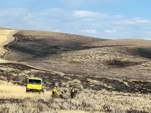
Planned Actions: Engines and Hand Crews are mopping up the fire edge and any remaining hotspots. Suppression Repair will continue on heavy equipment fire lines. Moffat County Road and Bridge road graders are used for this operation. Erosion prevention and soil stabilization occurs during this operaonal phase. As fire containment increases, fire resources will be demobilized off the Iron Fire.
Evacuations: No evacuations. Closures: Moffat County Road Closure will be lifted on Wednesday, October 4, 2023. Moffat County Road 17 is closed from County Road 7 to County Road 3. County Road 5 is closed from County Road 3 to County Road 7 for Firefighter and Public safety. Please observe closures and do not drive around or remove barricades.
Smoke: Smoke is not anticipated to impact any roadway directly. Go to htps://www.airnow.gov/ to view local airsheds and National Smoke Report.
Aviation Safety: Aircraft operations are not anticipated for the Iron Fire. Fire aviation resources are flying at different altitudes and speeds. Pilots should exercise caution when flying near wildfires to keep everyone safe. Unmanned aircrati systems (UAS) or drones must never fly near wildfires, as UAS are difficult to see and drone pilots have no way of communicating with firefighting aircraft. The only UAS or drones able to fly are agency-owned and operated and have been assigned to work on the wildfire and have communication with air operations. Remember if you fly, we can’t!

Courtesy BLM
UPDATE Monday, Oct. 2 — The fire is 50% contained and receiving precipitation. There has been no growth in the fire.
Here is the press release from the Bureau of Land Management.
Iron Fire Update for 10/02/2023
Location: Approximately 18 miles Northwest of Craig, Colorado
Jurisdiction: Bureau of Land Management, Little Snake Field Office, Private, Moffat County
Discovered: 09/29/2023 11:56 a.m. Containment: 50%
Vegetation Type: Grass, Sagebrush Estimated size: 7,361 acres
Threatened Structures: 6
Current Status: The DFPC Multi-Mission Aircraft (MMA) was unable to fly due to weather, so no updated acreage is available; however, it is not anticipated that there will be a significant increase as most fire activity occurred inside the containment lines. Firefighters took advantage of moderated fire behavior and as a result, containment has increased to 50%. Additional resources have been added to the fire organization. One additional 20-person Hand Crew and a 6-person Engine Module bring the fire line personnel to 71. Crews will continue to focus on mopping up isolated areas still holding heat and expect to increase containment by the end of the day. The weather system moving in is expected to bring rain and chances of lightning. There is also a chance for a rain/snow mix on Tuesday morning. The Moffat County Sheriff’s Office, Moffat County Road and Bridge, Colorado Division of Fire Prevention and Control (DFPC), and Bureau of Land Management Northwest District Fire and Aviation continue collaborative efforts. Firefighters will remain on scene until 100% Containment is achieved.
Planned Actions: Engines and Hand Crews are mopping up the fire edge; interior pockets that are still holding heat and might threaten the line are the priority. In areas of fire containment, Suppression Repair has begun on heavy equipment fire lines. Moffat County Road and Bridge road graders are used for this operation. Erosion prevention and soil stabilization occurs during this operational phase.
Evacuations: No evacuations. Closures: Moffat County Road 17 is closed from County Road 7 to County Road 3. County Road 5 is closed from County Road 3 to County Road 7 for Firefighter and Public safety. Please observe closures and do not drive around or remove barricades.
Smoke: Smoke is not anticipated to impact any roadway directly. Go to htps://www.airnow.gov/ to view local airsheds and National Smoke Report.
Aviation Safety: Aircrati may still be used on the Iron Fire, as weather and winds allow. Fire aviation resources are flying at different altitudes and speeds. Pilots should exercise caution when flying near wildfires to keep everyone safe. Unmanned aircraft systems (UAS) or drones must never fly near wildfires, as UAS are difficult to see and drone pilots have no way of communicating with firefighting aircraft. The only UAS or drones able to fly are agency-owned and operated and have been assigned to work on the wildfire and have communication with air operations. Remember if you fly, we can’t!
Photos courtesy BLM
UPDATE at 1:45 p.m. Sunday, Oct. 1, from Patrick Kieran, the Fire Management Specialist for the Iron Fire, with the Bureau of Land Management.
The fire is 30% contained, no significant fire growth since the first shift, Friday, Sept. 29. The fire area has already received some precipitation today. Containment is expected to increase significantly after today, weather cooperating.
Press Release from Bureau of Land Management; Sunday, Oct. 1
Location: Approximately 18 miles Northwest of Craig, Colorado
Jurisdiction: Bureau of Land Management, Little Snake Field Office, Private, Moffat County
Discovered: 09/29/2023 11:56 a.m. Containment: 30%
Vegetation Type: Grass, Sagebrush Estimated size: 7,361 acres
Threatened Structures: 6
Current Status: The Iron Fire had minimal fire growth on Saturday, Sept. 30, despite high winds that grounded aircraft. The fire did not have significant growth outside of the Initial Attack footprint, with most activity occurring in interior islands of previously unburned fuels. Firefighters made progress in fire containment and suppression efforts. The increase in cloud cover and precipitation has lessened the fire behavior and has given firefighters the opportunity to increase fire containment safely. The Moffat County Sheriff’s Office, Moffat County Road and Bridge, Colorado Division of Fire Prevention and Control (DFPC), and Bureau of Land Management Northwest District Fire and Aviation have worked seamlessly throughout the Iron Fire. Due to these collaborative efforts firefighter and public safety was prioritized and maintained. Firefighters will remain on scene until 100% Containment is achieved. There are 45 firefighters currently on the Iron Fire.
Planned Actions: Engines, Hand Crews, and Heavy Equipment are working towards 100% Containment. Heavy Equipment continues to create direct fire line to increase containment while Engines and Hand Crews are mopping up and extinguishing along the fire’s edge. Once containment increases and fire lines are secure the BLM, Moffat County and the DFPC will assess the need for suppression repair on the heavy equipment cut lines. Suppression repair actions occur immediately post-fire to repair damages and minimized potential soil erosion or other impacts resulting from fire suppression activities.
Evacuations: No evacuations. Closures: Moffat County Road 17 is closed from County Road 7 to County Road 3. County Road 5 is closed from County Road 3 to County Road 7 for Firefighter and Public safety. Please observe closures and do not drive around or remove barricades.
Smoke: Smoke will be visible from Highway 13 and County Roads 3 and 7 but is not anticipated to impact any roadway directly. Go to htps://www.airnow.gov/ to view local airsheds and National Smoke Report.
Aviation Safety: Aircraft may still be used on the Iron Fire, as weather and winds allow. Fire aviation resources are flying at different altitudes and speeds. Pilots should exercise caution when flying near wildfires to keep everyone safe. Unmanned aircraft systems (UAS) or drones must never fly near wildfires, as UAS are difficult to see and drone pilots have no way of communicating with firefighting aircraft. The only UAS or drones able to fly are agency-owned and operated and have been assigned to work on the wildfire and have communication with air operations. Remember if you fly, we can’t!
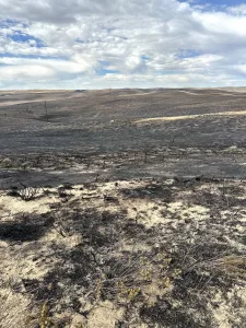
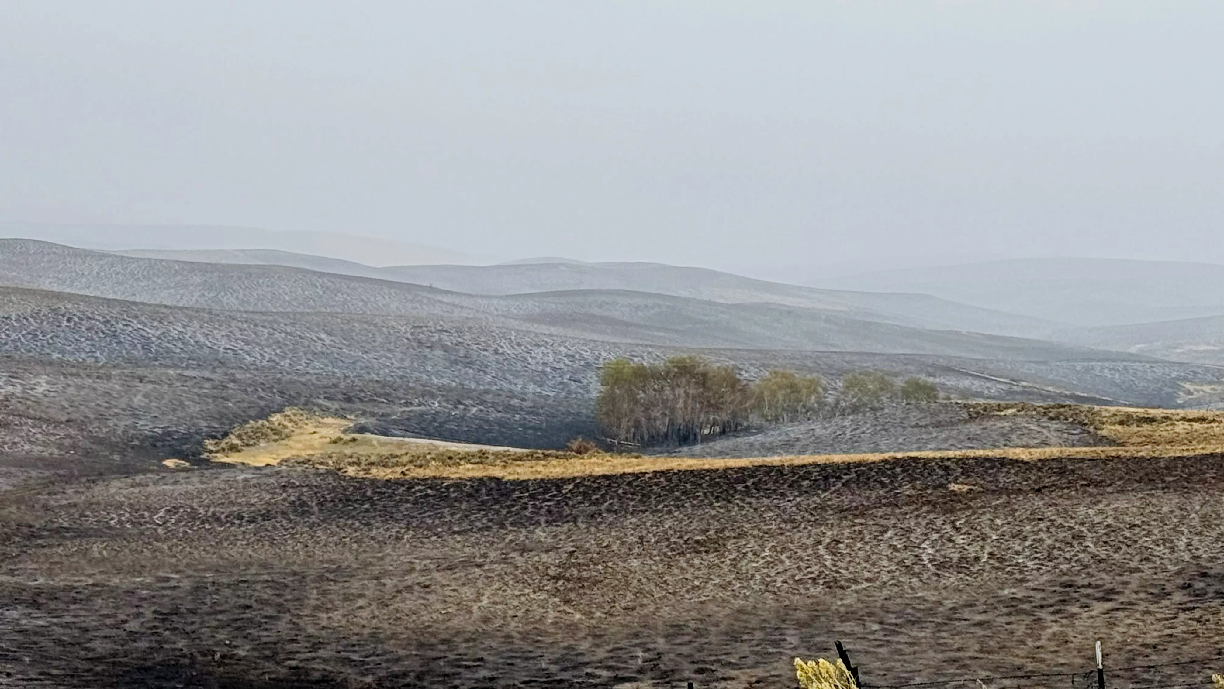
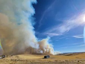
Picture of the burn area, from Patrick Kieran with the BLM. 2 p.m. Saturday, Sat. 30
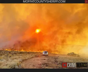
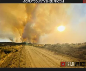
2:25 p.m. Update from Moffat County Sheriff’s Office. Link to Moffat County Sheriff’s Office on CrimeWatch.net
Location: Approximately 18 miles Northwest of Craig, Colorado.
Jurisdiction: Bureau of Land Management, Little Snake Field Office, Private, Moffat County
Discovered: 09/29/2023 11:56 a.m. Cause: Under Investigation
Vegetation Type: Grass, Sagebrush
Estimated size: 7,361 acres
Containment: 0%
Threatened Structures: 6 Current
Status: The Iron Fire started Friday, September 29th at 11:56 a.m. There was rapid rates of spread and extreme fire behavior observed. Gusty winds, receptive fuel bed, remote, and rugged terrain led to initial large fire growth. Ground and aviation resources responded conducting suppression operations throughout the shift. The Northwest Interagency Fire Type 3 Team assumed command. Engines, Hand Crews, Heavy Equipment, and Aviation worked together past sundown.
Currently, there are 54 firefighters working towards full containment.
Red Flag Warning is in effect today due to gusty winds, critical fuels and low humidities. Winds could reach 40 mph this afternoon on the fire location. Winds are expected to reach 45 mph on Sunday, October 1st. The fire area has a 40% of precipitation on Monday October 2nd.
Planned Actions: Northwest Interagency Fire Type 3 Team has mixed suppression resources and are working toward 100% Containment of the Iron Fire. Utilizing roads, trails, bulldozer lines, Engines and Hand Crews can perform suppression actions. Aviation is still committed and can be used until wind speeds does not permit.
Evacuations: No evacuations.
Closures: Moffat County Road 17 is closed from County Road 7 to County Road 3. County Road 5 is closed from County Road 3 to County Road 7 for Firefighter and Public safety.
Smoke: Smoke will be visible from Highway 13; County Road 3 and 7. Smoke is not anticipated to impact any roadway directly. Go to https://www.airnow.gov/ to view local airsheds and National Smoke Report.
Aviation Safety: Aircraft is still being used on the Iron Fire. Fire aviation resources are flying at different altitudes and speeds. Pilots should exercise caution when flying near wildfires to keep everyone safe. Unmanned aircraft systems (UAS) or drones must never fly near wildfires, as UAS are difficult to see and drone pilots have no way of communicang with firefighting aircraft. The only UAS or drones able to fly are agency owned and operated and have been assigned to work on the wildfire and have communicatuon with air operations. Remember if you fly, we can’t! For updated information follow: htps://www.facebook.com/BLMColoradoFire Location
Sourced via CRIMEWATCH®: https://crimewatch.net/us/co/moffat/sheriff/153578/broadcasts/update-iron-fire
Noon Saturday — The BLM has hired a Public Information Officer. They will be sending a press release soon. He said there is a Red Flag Warning today and tomorrow for the area and winds were at 25 mph this morning.
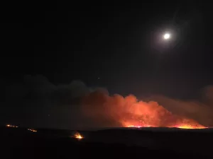
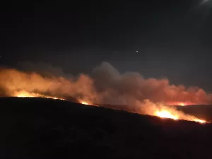
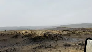
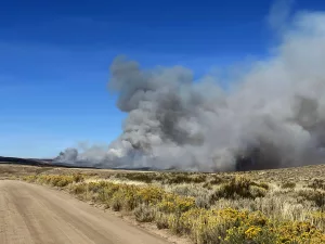
10 p.m. Friday Photos of the fire on Friday night, courtesy Shara Cole.
The Denver networks are covering the fire in the news.
7:20 p.m. Friday —From Yampa Valley Electric — As a result of the fire, we had one breaker open up and we have de-energized an additional section of the line as the fire encroaches on more of our infrastructure. We currently have 18 members without power. We know that four poles will need to be replaced, but due to this being an active wildfire, we do not have an ETA on when the poles will be replaced or power being restored. We will post more as information becomes available.
UPDATE 6:25 p.m. from the Moffat County Sheriff’s Office.
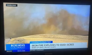
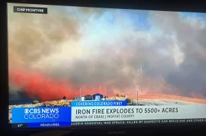
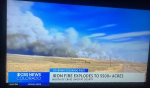
Update on the Iron Fire estimates size in excess of 5,500 acres. Crews are actively working to contain the fire with several air crews including eight small engine air tankers, two helicopters, Moffat County Fire Engines, BLM, and several Moffat County motor graders.
Sourced via CRIMEWATCH®: https://crimewatch.net/us/co/moffat/sheriff/153578/broadcasts/iron-fire-update
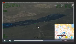
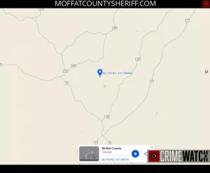
Map Reference from Shara Cole. Coordinates are 40.76470, -107.77046
Update at 5:25 p.m. Chip McIntyre with the Moffat County Sheriff’s Office says the fire is at 5,500 acres.
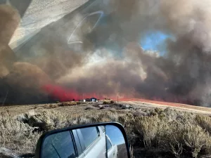
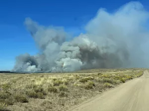
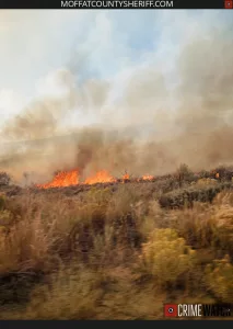
Update 5:12 p.m. Photo courtesy Chip McIntyre with the Moffat County Sheriff’s Office.
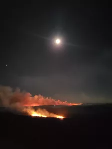
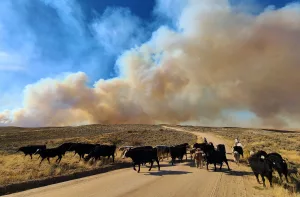
Update 5:13 p.m. Shara Cole sends this picture and writes, “It’s 1/4-mile from my property now. I’m so sad for our neighbors who have houses there.”
A fire is burning in Moffat County, near county roads 5 and 17. This is about 25 miles northwest of Craig. Moffat County Sheriff’s Office says the fire is being called the Iron Fire, and it is estimated to be about 170 acres. It’s burning in an area of an old burn from 2018 in tall grass and sagebrush. High winds are pushing the fire in a northern direction from Moffat County Road 17.
The public is being asked to stay clear of the area. We have been asked to relay this message several times.
Carly Davidson with Yampa Valley Electric writes, ““We have a line in the area that serves 14 members. We have been in talks with the Moffat County Sheriff and they have not indicated that we will need to de-energize the line at this point.”
Moffat County Sheriffs Office is sending reports. They say wildfire crews along with the Bureau of Land Management and Craig Fire are actively fighting the fire right now. The cause is undetermined.
We will keep you updated.
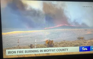
Video of the fire from Chip McIntyre with the Moffat County Sheriff’s Office